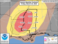
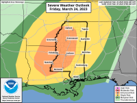
We have now been upgraded to an enhanced threat as things look to be coming into place for a significant severe weather event. In previous days the question was whether or not there would be sufficient instability for the storms to use as fuel. Strong deep layer shear was already going to be present. It looks to be in place setting the stage for intense supercells capable of producing strong tornadoes over western parts of MS before growing upscale into a line. While timing will be refined, storms look to affect the western parts of the state late afternoon into the early evening and then move across the state overnight.
www.patreon.com/NMSCAS
www.patreon.com/NMSCAS
Attachments
-
 89C564F4-3EB3-43E3-B294-DC6510F05EE2.png380.2 KB · Views: 19
 -
 80C4387F-D5A2-436C-B38A-9D07963F092E.png352.5 KB · Views: 16
