Next Possible Severe Threat

Hugh's Burner Phone

Well-known member
Aug 3, 2017
4,300
3,427
113
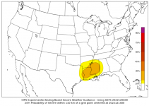
Could possibly be getting a severe threat in the region next Tuesday / Wednesday. The SPC has already outlined a threat area over the ARKLATEX Tuesday and is mentioning possibly adding one for the lower MS valley on Wednesday. The latest run of the GFS just now coming in is more progressive and trying to bring it through our area on Tuesday so just have to see how the timing plays out as we get closer. Below is the CIPS analog showing it picking up on the threat for next Wednesday. Still plenty of time to watch this and see how it evolves, but wanted to let you know that it at least looks possible.

download.png
 

Drebin

Well-known member
Aug 22, 2012
16,821
13,730
113
Could possibly be getting a severe threat in the region next Tuesday / Wednesday. The SPC has already outlined a threat area over the ARKLATEX Tuesday and is mentioning possibly adding one for the lower MS valley on Wednesday. The latest run of the GFS just now coming in is more progressive and trying to bring it through our area on Tuesday so just have to see how the timing plays out as we get closer. Below is the CIPS analog showing it picking up on the threat for next Wednesday. Still plenty of time to watch this and see how it evolves, but wanted to let you know that it at least looks possible.

View attachment 274656
Come The Rock GIF by WWE
 

Hugh's Burner Phone

Well-known member
Aug 3, 2017
4,300
3,427
113
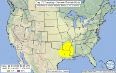
The SPC has now highlighted most of west MS in a severe threat for next Tuesday. Details still remain to be hashed out, but at this time all modes of severe weather look to be possible and wind profiles will support supercells.

spccoday7.severe.latest.png
 

ronpolk

Well-known member
May 6, 2009
8,119
2,609
113
You’re saying I should go ahead and plan for my daughters school to plan an early release and it won’t even rain at my house?**

Kidding cause I know it got bad in several places around the state a couple weeks ago… however, madison schools are on a bad track record the last few years of releasing school and it not even raining.
 

OG Goat Holder

Well-known member
Sep 30, 2022
7,683
7,253
113
You’re saying I should go ahead and plan for my daughters school to plan an early release and it won’t even rain at my house?**

Kidding cause I know it got bad in several places around the state a couple weeks ago… however, madison schools are on a bad track record the last few years of releasing school and it not even raining.
That's the funny thing about social media. I remember back 15 years or so ago, we'd get this alert, and 99% of the area wouldn't get anything but a little heavy rain. Confidence in the weather man was at an all time low. But now, you can actually see the area that DID get hit, in a matter of 4-5 phone clicks. So, the weather man can confirm that he was 'right'. But it still doesn't make up for the freakout they cause to be 1% right.

Better safe than sorry I suppose, and most people are stupid, and won't listen unless it's right under their nose.
 

Hugh's Burner Phone

Well-known member
Aug 3, 2017
4,300
3,427
113
Better safe than sorry I suppose, and most people are stupid, and won't listen unless it's right under their nose.
That is the main reason I storm chase. Research has shown that people are close to 80% more likely to take shelter if they have visual proof a tornado is happening. So that is why I try to get out there and get pictures/video to send in to the NWS and media outlets.

Also, I'm not sure if all of you know, but there are different levels of tornado warnings that are issued based on certain criteria. These are standard across all NWS offices so doesn't matter where you live. Here is the verbiage you look for:

Severe thunderstorm capable of producing a tornado. Lowest confidence warning. Simply means that strong low level rotation has been detected on radar. No confirmation a tornado exists either from a chaser or radar signature. One could still be on the ground but hasn't been seen or too far from a radar site for it to detect debris.

Severe thunderstorm producing a tornado. This level warning is usually issued when there has been no visual confirmation, but radar has detected a debris signature indicating a tornado is on the ground producing damage and lofting debris into the air high enough for the radar to see it.

Confirmed tornado. Can be used interchangeably with the previous warning level, but one that has been confirmed visually will get this level warning,

PDS (Particularly Dangerous Situation) or Tornado Emergency. Highest level warning. This is a tornado that is confirmed either by radar or visually and is affecting, or about to affect a populated area. If it is not affecting a population center it will never get this level warning. Doesn't matter how big or violent it is.
 
Get unlimited access today.

Pick the right plan for you.

Already a member? Login