Severe Threat for Friday

Hugh's Burner Phone

Well-known member
Aug 3, 2017
4,294
3,418
113
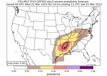
As expected, the SPC has introduced a severe threat for this Friday. Strong deep layer shear will be present and moisture looks to be sufficient to support severe weather. Still too early know specifics as to what type of storm mode and severe weather will be favored, but that will be ironed out in future updates. The GFS has also been consistent the last few days of an even more potent severe threat for that Sunday, too, but other models are in disagreement. Just something to watch.

www.patreon.com/NMSCAS


E21D7BE2-374A-4579-BA14-D32F1E02FD2E.png
 
Last edited:

Hugh's Burner Phone

Well-known member
Aug 3, 2017
4,294
3,418
113
Risk for MS has stayed pretty much the same. Looking risk may be the most for central and south MS. An existing squall line should push into the state and could re-intensify as we get to the peak heating of the day. A few discrete supercells could also form out ahead of the main line

www.patreon.com/NMSCAS


Maroon Eagle

Well-known member
May 24, 2006
16,467
5,405
102
What does Thursday night look like?

Since the sports seasons are over with, I’m planning on seeing Joshua Ray Walker at the Sundown in Ruston, Louisiana…

He performed on CBS Saturday Morning (well, Saturday morning) & his voice and songwriting are amazing:


cling84

Member
Aug 22, 2012
37
38
18
Will the atmosphere have enough time from Friday to Sunday to create such short-term convection? I always thought it took several days after the passage of a cold front for the atmosphere to become "severe weather" unstable...
 

Hugh's Burner Phone

Well-known member
Aug 3, 2017
4,294
3,418
113
Will the atmosphere have enough time from Friday to Sunday to create such short-term convection? I always thought it took several days after the passage of a cold front for the atmosphere to become "severe weather" unstable...
Oh yes. It can do it in a matter of hours if the conditions are right. A prime example was a certain tornado outbreak which shall remain nameless due to people automatically thinking we're saying this next event is going to be like that one whenever it comes up.

This event is showing more signs of weakening than it is intensifying. While some of the analogs are still showing a solid event, a lot of the models are going the exact opposite and all but sticking a fork in it. The 00Z run of the GFS and Euro along with the overnight update from the SPC will be interesting to see where they take things. I'll just say I've gone from borderline certain I was chasing to a wait and see holding pattern.
 

cling84

Member
Aug 22, 2012
37
38
18
Thanks. I don't know why "that event" slipped my mind... storms in the morning with more in the afternoons. Thanks for the reminder...
 

IBleedMaroonDawg

Well-known member
Nov 12, 2007
23,106
7,119
113
It is Spring now so the threat changes every new forecast modeling cycle. I would pay attention since it looks like there should be enough potential energy available for a system to tap into. Events also can reach severe limits easier because we are really entering a time frame we are more likely to have warm and humid air already in place to work with.
 

Hugh's Burner Phone

Well-known member
Aug 3, 2017
4,294
3,418
113
63D9B896-C638-4280-B3A6-64014B544FBC.png

There is still a large model discrepancy regarding this system. The SPC summarizes it pretty well so I'll just let them give the details:
The most recent GFS shows an intense low-level jet over a large portion of LA and MS, with conditions favorable for supercells. CSU machine-learning probabilities have picked up on these favorable conditions and currently suggest a high probability of severe thunderstorms from northern LA across northern/central MS into Middle TN. However, recent guidance for the ECMWF and CMC does not match the intensity of the low-level jet from the GFS. Additionally, these models have shown more run-to-run consistency over the past few days. Severe thunderstorms are still possible across the Lower MS Valley into the Southeast and Mid-South on Friday, but all of the factors mentioned above preclude introducing higher severeprobabilities with this outlook.

www.patreon.com/NMSCAS
 

AstroDog

Well-known member
Oct 5, 2022
1,298
844
113
Looks like guaranteed to rain during ballgame at 6 pm this Friday and only increases as the game continues. Maybe we should go for a DH on Saturday where it looks like no rain.
 

Uncle Ruckus

Well-known member
Apr 1, 2011
11,864
2,019
113
Looks like guaranteed to rain during ballgame at 6 pm this Friday and only increases as the game continues. Maybe we should go for a DH on Saturday where it looks like no rain.
Maybe we should just cancel all 3
 

Shmuley

Well-known member
Mar 6, 2008
22,290
5,183
113
Risk for MS has stayed pretty much the same. Looking risk may be the most for central and south MS. An existing squall line should push into the state and could re-intensify as we get to the peak heating of the day. A few discrete supercells could also form out ahead of the main line

www.patreon.com/NMSCAS


Hugh, is it now an Enhanced risk for central Mississippi on Friday ?

and how about Sunday as well?

possible that all 3 this weekend are washouts? [/crosses fingers].
 

Hugh's Burner Phone

Well-known member
Aug 3, 2017
4,294
3,418
113
Hugh, is it now an Enhanced risk for central Mississippi on Friday ?

and how about Sunday as well?

possible that all 3 this weekend are washouts? [/crosses fingers].
It is now enhanced. Sunday could possibly be another severe event but not to the level this one is.
 

IBleedMaroonDawg

Well-known member
Nov 12, 2007
23,106
7,119
113
We've had so many near misses the last couple years that is just made me the weather guys I know who follow these things a little gun shy until the threat is more eminent. They have started to chirp it up a little bit more about this event and another system possibly on Sunday.

PRALLC05_gfs215F072.png
 

Attachments

  • day3_nospc_latest_1.jpg
    day3_nospc_latest_1.jpg
    62.3 KB · Views: 4
Get unlimited access today.

Pick the right plan for you.

Already a member? Login