Severe Weather Friday Round 2...Fight

Hugh's Burner Phone

Well-known member
Aug 3, 2017
4,294
3,418
113
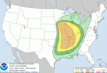
Off the bat...this one doesn't look to park near the punch of last Friday even though there is still some forecast uncertainty. The core of this system will be further north so the best forcing and wind fields will be displaced to our north. However, the best moisture return will be down in our area noted by forecast mid 60's dew points. Wind shear will be good enough to support at some level of severe threat over MS...particularly the extreme NW part of the state where an enhanced risk resides with a slight risk covering the rest of the north and most of the central part of the state. Storm mode looks to be a mix of discrete supercells and linear. Timing is not nailed down yet but expect late afternoon into the overnight hours depending on your part of the state.
www.patreon.com/NMSCAS

13BA86A3-5F5A-42E4-AF69-4CA76096E240.png
 

Hugh's Burner Phone

Well-known member
Aug 3, 2017
4,294
3,418
113
The SPC has expanded the enhanced risk to cover more of north MS as some of the models continue to show an uptick in intensity further south and east than earlier runs. The SPC mentions potentially intense and widespread severe weather possible Friday afternoon and night. Storm mode looks to favor and mixture of discrete supercells and linear convection. I still don't think things are looking like a repeat of last Friday, but things are trending stronger. That said, the synoptic set up is different with this storm than last week which is what I think will keep it from being not quite as intense as last week. I'm hoping I'm right about this.

www.patreon.com/NMSCAS

4E486DD7-337A-420E-A066-943B4671A86F.png09221438-CE53-4128-8913-15761073D5BC.png
 
  • Like
Reactions: dorndawg

Trazom

Member
Mar 26, 2023
20
39
13
The SPC has expanded the enhanced risk to cover more of north MS as some of the models continue to show an uptick in intensity further south and east than earlier runs. The SPC mentions potentially intense and widespread severe weather possible Friday afternoon and night. Storm mode looks to favor and mixture of discrete supercells and linear convection. I still don't think things are looking like a repeat of last Friday, but things are trending stronger. That said, the synoptic set up is different with this storm than last week which is what I think will keep it from being not quite as intense as last week. I'm hoping I'm right about this.

www.patreon.com/NMSCAS

View attachment 323145View attachment 323146
Thanks for all you do HBP. Where can I find that forecast product with the Mississippi detail. All I can find from the SPC is this one:
 

Attachments

  • 99822F74-9CB2-494E-AD39-302908C22E01.gif
    99822F74-9CB2-494E-AD39-302908C22E01.gif
    29 KB · Views: 1

Drebin

Well-known member
Aug 22, 2012
16,810
13,700
113
I think the one Friday will affect MO and IA more. We're pretty much on the southern periphery of this system.
Yes, but I read something from SPC that stated they were really concerned with the setup in the southern end of the enhanced area. There are a couple of failure modes that have to be overcome though.
 

Car Ramrod.sixpack

Active member
Sep 21, 2017
693
314
63
Yep, and conditions are potentially shaping up for major flooding on the Lower MS River. Just what we need (SMH).
AR is going to be in some trouble if they and MO keep getting these types storms. I was in northern west AR this past weekend and every river I drove across was nearing or out of their banks. The large flood control lakes (Beaver, Table Rock, Bull Shoals, Norfork, and Greer's Ferry) are above top of power pool and well into their conservation pool levels. Its not good for these lake to be this far into their capacity this early. It wouldn't surprise me that you will see more spillway release to bring the lake levels down rather than hydro generation. This is not good for the trout population or flooding in the lower white and lower MS River.
 

Hugh's Burner Phone

Well-known member
Aug 3, 2017
4,294
3,418
113
Yes, but I read something from SPC that stated they were really concerned with the setup in the southern end of the enhanced area. There are a couple of failure modes that have to be overcome though.
They upgraded a small area near Memphis to a mod risk. I just haven't had a chance to post anything.
 

stateu1

Well-known member
Mar 21, 2016
2,565
585
113
AR is going to be in some trouble if they and MO keep getting these types storms. I was in northern west AR this past weekend and every river I drove across was nearing or out of their banks. The large flood control lakes (Beaver, Table Rock, Bull Shoals, Norfork, and Greer's Ferry) are above top of power pool and well into their conservation pool levels. Its not good for these lake to be this far into their capacity this early. It wouldn't surprise me that you will see more spillway release to bring the lake levels down rather than hydro generation. This is not good for the trout population or flooding in the lower white and lower MS River.
A quick look at Bull Shoals data says 13ft over power pool and they a hardly generating now.
I have fished on the white around the time of spillway release and it was fantastic. Every fish we caught had a wad of crawlers in their throat from them being washed in from the banks.
 

Car Ramrod.sixpack

Active member
Sep 21, 2017
693
314
63
A quick look at Bull Shoals data says 13ft over power pool and they a hardly generating now.
I have fished on the white around the time of spillway release and it was fantastic. Every fish we caught had a wad of crawlers in their throat from them being washed in from the banks.
I fish the white quite often and check the generation schedule almost daily. Up until last Saturday for the past 2 weeks they were running 5-6 units 24/7. Since Friday evening they have throttled down to 1-2 units. They only do this when the lower white is at or approaching flood stage.
 

Hugh's Burner Phone

Well-known member
Aug 3, 2017
4,294
3,418
113
Here is the latest update. The enhanced risk has been pushed south along for severe wind. The tornado threat has also been expanded slightly. Significant and long track tornadoes will be possible in the hatched area. Timing looks to be late afternoon for the NW part of the state going into the overnight hours. Discrete storms should be the primary storm mode in the afternoon growing upscale into a QLCS linear event during the night.

www.patreon.com/NMSCAS


  • Like
Reactions: aTotal360

IBleedMaroonDawg

Well-known member
Nov 12, 2007
23,105
7,119
113
Here is the latest update. The enhanced risk has been pushed south along for severe wind. The tornado threat has also been expanded slightly. Significant and long track tornadoes will be possible in the hatched area. Timing looks to be late afternoon for the NW part of the state going into the overnight hours. Discrete storms should be the primary storm mode in the afternoon growing upscale into a QLCS linear event during the night.

www.patreon.com/NMSCAS

There was some talk that they were gonna expand it across from North Mississippi. For some reason they're more worried about the extreme northern part of the state and Delta but the biggest threat seems to be over in Arkansas and Southern Missouri.
 

Hugh's Burner Phone

Well-known member
Aug 3, 2017
4,294
3,418
113
There was some talk that they were gonna expand it across from North Mississippi. For some reason they're more worried about the extreme northern part of the state and Delta but the biggest threat seems to be over in Arkansas and Southern Missouri.

This is a bi-modal storm as it has two main threat areas. I do think people in eastern and northeastern AR need to be very weather aware tomorrow afternoon.


IBleedMaroonDawg

Well-known member
Nov 12, 2007
23,105
7,119
113
I just got off the phone with my mother. I have not spoken to her since the storm hit. Still can't get through on the conventional phone but she finally had a chance to call me on her cell phone. She said it's still bad in Amory, and Wren and Smithville and she is not looking forward to the chances of another storm tomorrow night. She's most worried about is the trees that were weakened by this last storm that may come down with more rain and strong winds. The tornado actually came thru a half a mile from her house. I really hope tomorrow night is a bust at least in Monroe County and over around Rolling Fork
 
Get unlimited access today.

Pick the right plan for you.

Already a member? Login