Still too early to talk details, but next Wednesday and Thursday look to be active severe weather days.
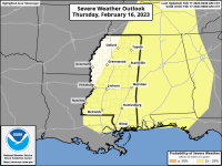
View attachment 308649
View attachment 308649

Anybody saying outbreak and high risk right now needs to have their keyboard shoved where the sun refuses to shine. While a few parameters are looking good, there's nothing pointing this to be that high end of an event right now. Not saying it couldn't change, though. Once the mid range models come into play we'll have a better idea.I was just reading about that. It's far enough away not to get excited about yet, but they're using the wrong terms like "30% high risk areas" & "major severe weather outbreak". At first glance, I'm afraid it might be too large of an area to translate into large tornado event. That's what I'm hoping for right now anyway.
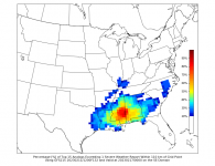
View attachment 309102
Well, that's what they were saying yesterday that's not what they're saying today. I've learned the hard way not to pay much attention to a couple of days before and not write anything in stone till the day before and that could change as well because after all, it's just wind, water, and temperature. If you live anywhere in the south, it can change 20° in one day.Anybody saying outbreak and high risk right now needs to have their keyboard shoved where the sun refuses to shine. While a few parameters are looking good, there's nothing pointing this to be that high end of an event right now. Not saying it couldn't change, though. Once the mid range models come into play we'll have a better idea.
GFS certainly trending that way.A lot of time between now and then. Could be a nothingburger.
All of our weather balloons are being shot down making an accurate forecast almost impossible.Well, that's what they were saying yesterday that's not what they're saying today. I've learned the hard way not to pay much attention to a couple of days before and not write anything in stone till the day before and that could change as well because after all, it's just wind, water, and temperature. If you live anywhere in the south, it can change 20° in one day.