Significant Severe Weather Event Expected Friday

Hugh's Burner Phone

Well-known member
Aug 3, 2017
4,294
3,418
113
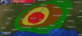
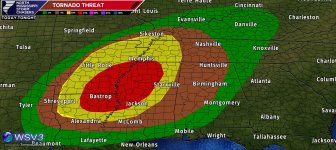
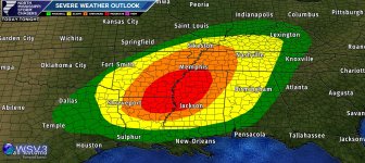
The SPC has upgraded western MS to a moderate risk for Friday driven by the threat for several tornadoes, some of which could be strong. All of the parameters look to be coming together for a classic spring severe event. Storm mode looks to initially favor discrete supercells capable of all weather modes starting Friday afternoon over parts of LA and AR. These storms will advance east into western MS late evening into the overnight hours eventually forming into a broken line of bowing segments. Even after this transition, tornadoes will still be possible. Exact timing of these storms and their evolution from discrete to more linear are still up in the air, it if you live in or near the moderate risk area be prepared for severe weather starting late afternoon.

www.patreon.com/NMSCAS
9922FA24-A3BD-411E-8A15-938711687ECB.png1DDC581D-8398-4BAB-9334-E1ACC20B783D.png
 

Cantdoitsal

Well-known member
Sep 26, 2022
3,359
2,705
113
My 82 yr old Mom is still kicking in Jacktown. Any updates from there? Thanks for the post.
 

Hugh's Burner Phone

Well-known member
Aug 3, 2017
4,294
3,418
113
My 82 yr old Mom is still kicking in Jacktown. Any updates from there? Thanks for the post.
Jackson is on the edge of the moderate risk so she will need to be weather aware and have some way to get warnings during the night. I can't recommend enough a NOAA weather radio with SAME technology.
 
  • Like
Reactions: Cantdoitsal

Cantdoitsal

Well-known member
Sep 26, 2022
3,359
2,705
113
Jackson is on the edge of the moderate risk so she will need to be weather aware and have some way to get warnings during the night. I can't recommend enough a NOAA weather radio with SAME technology.
I'll remind her today once she wakes up. I remember about 8 years ago or so maybe longer a brick house directly across the street from her was 1/2 way demolished (no injuries) but her's wasn't touched. Naders can be some weird things.
 

8dog

Well-known member
Feb 23, 2008
12,268
3,220
113
The SPC has upgraded western MS to a moderate risk for Friday driven by the threat for several tornadoes, some of which could be strong. All of the parameters look to be coming together for a classic spring severe event. Storm mode looks to initially favor discrete supercells capable of all weather modes starting Friday afternoon over parts of LA and AR. These storms will advance east into western MS late evening into the overnight hours eventually forming into a broken line of bowing segments. Even after this transition, tornadoes will still be possible. Exact timing of these storms and their evolution from discrete to more linear are still up in the air, it if you live in or near the moderate risk area be prepared for severe weather starting late afternoon.

www.patreon.com/NMSCAS
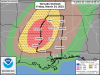
View attachment 321264View attachment 321265
Not as important but do we anticipate the game
Tomorrow getting washed?
 
  • Like
Reactions: onewoof

Hugh's Burner Phone

Well-known member
Aug 3, 2017
4,294
3,418
113
Not as important but do we anticipate the game
Tomorrow getting washed?
Doubtful. The system will probably be well after dark getting here, but a couple of renegade discrete cells ahead of the main system could always wreak some havoc. The warm sector tomorrow will be wide open so not out of the question to see some storms here earlier.
 

Hugh's Burner Phone

Well-known member
Aug 3, 2017
4,294
3,418
113
And just in case anybody is interested, myself and at least one other chaser from our team will be out tomorrow targeting the delta region. Assuming we get some daytime storms and decent cell coverage, we will both be live streaming our chases on our patreon page (link above) for our premiere members ($5/Month). Just in case anybody is interested.
 

GhostOfJackie

Active member
Apr 20, 2009
3,573
371
83
And just in case anybody is interested, myself and at least one other chaser from our team will be out tomorrow targeting the delta region. Assuming we get some daytime storms and decent cell coverage, we will both be live streaming our chases on our patreon page (link above) for our premiere members ($5/Month). Just in case anybody is interested.
I'm debating whether or not I want to waste my time with this one. Delta-good, nighttime-bad. Color me undecided, but Brandon Clement will be out. There are some things in this world that are certain.
 

Hugh's Burner Phone

Well-known member
Aug 3, 2017
4,294
3,418
113
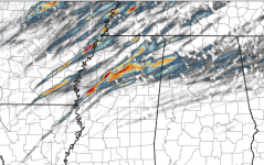
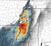
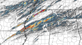
A couple of things I wanted to point out on this system is what the HRRR (High Res Short Term Model) has to say. The two graphics below show the forecast 0-3km updraft helicity tracks and the Significant Tornado Parameter tomorrow evening. The helicity track is where this model run thinks that supercells with strong low level rotations will form and move. Now, if you are under one of these tracks don't panic, and if you are not near one don't breathe easy. These change with every run. It just gives an idea that the HRRR is fairly confident that conditions will be favorable for intense supercells with strong low level rotation. The STP is a value created by some rather advanced formulas that calculates the storms system's capability to produce strong to violent (EF2+ tornadoes). Again, don't get caught up on where the bright colors are, just the fact that there are bright colors. There are still a couple things that could affect the ceiling for this storm, but if those don't happen then this could be a very significant event.

Updrafts.png STP.png
 
  • Like
Reactions: IBleedMaroonDawg

onewoof

Well-known member
Mar 4, 2008
9,696
5,825
113
Doubtful. The system will probably be well after dark getting here, but a couple of renegade discrete cells ahead of the main system could always wreak some havoc. The warm sector tomorrow will be wide open so not out of the question to see some storms here earlier.
so they won't move the game up on Friday to earlier? what about Sunday? just getting your guess to see if we have a double header Saturday
 

Hugh's Burner Phone

Well-known member
Aug 3, 2017
4,294
3,418
113
so they won't move the game up on Friday to earlier? what about Sunday? just getting your guess to see if we have a double header Saturday
As of right now I am not anticipating a move on Friday although it would be possible if they're operating out of an abundance of caution. As of right now it looks like storms won't affect this area until around midnight. Sunday is looking like there could be storms in the area again, so they may well consider a Saturday double header.
 
  • Like
Reactions: IBleedMaroonDawg

Hugh's Burner Phone

Well-known member
Aug 3, 2017
4,294
3,418
113
What is the timing tomorrow for Scott/Smith county area?
Probably 9:00-10:00pm.

But I need everybody to remember that when I give a time range that is for the main group of storms. It's always possible with systems like this that are favoring discrete convection that a storm well out ahead of that may form and move over your area. All of these times need to be taken with a grain of salt.
 

IBleedMaroonDawg

Well-known member
Nov 12, 2007
23,106
7,119
113
As of right now I am not anticipating a move on Friday although it would be possible if they're operating out of an abundance of caution. As of right now it looks like storms won't affect this area until around midnight. Sunday is looking like there could be storms in the area again, so they may well consider a Saturday double header.
I haven't been too worried about this system till the latest models. Even if we don't have a big outbreak the potential environment in West MS, East AR, and Northern LA has started looking more favorable for strong, long-tracking tornadoes. The MS Delta looks like the place to chase
 

Drebin

Well-known member
Aug 22, 2012
16,810
13,700
113
I haven't been too worried about this system till the latest models. Even if we don't have a big outbreak the potential environment in West MS, East AR, and Northern LA has started looking more favorable for strong, long-tracking tornadoes. The MS Delta looks like the place to chase
These are the ones that end up blasting us...the ones that come together late. We've had a few "busts" in a row that looked scary for four days and then didn't materialize. This one is different.
 

DonDon.sixpack

New member
Aug 31, 2012
59
1
8
Look out Yazoo City again. Hoping it doesn't get real bad out ay my house near Morton. We have NO sirens out our way
 

Hugh's Burner Phone

Well-known member
Aug 3, 2017
4,294
3,418
113
My personal belief is that they are incorrect on their 15% area. I think it needs to be shifted further north by about 75 miles and extended into east Mississippi and western Alabama.
The way things have been trending I would have a hard time arguing about a northward shift or expansion. I'm no sold on the eastward movement yet. I am still holding solid on Leland as where I am staging tomorrow. Got good roads all 4 directions. Wish that Mennonite bakery was still open there. If it were I would be making a stop.
 

IBleedMaroonDawg

Well-known member
Nov 12, 2007
23,106
7,119
113
These are the ones that end up blasting us...the ones that come together late. We've had a few "busts" in a row that looked scary for four days and then didn't materialize. This one is different.
I hope you're wrong, but I feel the same way. If we get any pre-frontal storms to form they might get really scary for Western Mississippi.
 

IBleedMaroonDawg

Well-known member
Nov 12, 2007
23,106
7,119
113

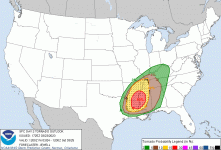
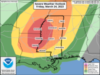
SPC Outlook​

12:25 Update

Lower MS Valley​

The air mass will destabilize across this area well into the evening, which will remain open warm sector with the cold front stalling to the west. Severe weather is most likely late in the day and evening as low-level moisture remains favorable, gradual cooling aloft occurs, and the low-level shear increases substantially. The fact that convergence will be subtle may be beneficial to the supercell tornado threat, and deepening bands of convection may eventually produce tornadoes from northern LA into central MS. Even if storms in this area remain isolated, impressive hodographs with 0-1 SRH over 300 m2/s2 will favor supercells and tornadoes, perhaps tracking for long distances given the lack of cold/stable air. Therefore despite perhaps a weaker model signal over these southern areas, the Moderate Risk has been maintained.

day2probotlk_torn.gif
 

Hugh's Burner Phone

Well-known member
Aug 3, 2017
4,294
3,418
113
I hope you're wrong, but I feel the same way. If we get any pre-frontal storms to form they might get really scary for Western Mississippi.
And as of right now that is what is anticipated. Even when they grow upscale into a QLCS wind profiles might keep them as bowing segments and a broken line keeping the tornado threat stronger than it would be otherwise.
 

Hugh's Burner Phone

Well-known member
Aug 3, 2017
4,294
3,418
113
Here is the updraft helicity forecast based off the 18Z HRRR six hours from the one above. Not a lot of difference. This one has a couple extra tracks and a couple stronger tracks. So the model runs are not showing any type of weakening trend.


Helicity.png
 

Shmuley

Well-known member
Mar 6, 2008
22,290
5,183
113
Dear Mississippi River Counties and Delta Counties, hold onto your a s s. NWS is saying long track tornadoes "likely" on Friday evening/night. Haven't seen that word used recently.
 

onewoof

Well-known member
Mar 4, 2008
9,696
5,825
113
Friday game moved up to 5PM

Hopefully we experience no severe events from Vandy batters
 

Drebin

Well-known member
Aug 22, 2012
16,810
13,700
113
The way things have been trending I would have a hard time arguing about a northward shift or expansion. I'm no sold on the eastward movement yet. I am still holding solid on Leland as where I am staging tomorrow. Got good roads all 4 directions. Wish that Mennonite bakery was still open there. If it were I would be making a stop.
I don't think the area needs to be shifted east. I still think the delta is ground zero. I just think it needs to be expanded a little bit eastward.
 

IBleedMaroonDawg

Well-known member
Nov 12, 2007
23,106
7,119
113
I don't think the area needs to be shifted east. I still think the delta is ground zero. I just think it needs to be expanded a little bit eastward.
I think it depends on the lower level jet right now it shows it really ramping up over the Mississippi Delta right at the Mississippi River. If it materializes, we're gonna have a very busy evening.
 
Get unlimited access today.

Pick the right plan for you.

Already a member? Login