Significant Severe Weather Threat Thursday

Hugh's Burner Phone

Well-known member
Aug 3, 2017
4,296
3,420
113
B9E75F99-6211-4213-BA2D-F4FDC51DB162.png

SPC has issued a Day 5 enhanced threat. To add to things, as of right now the timing looks to push the storms through overnight. SPC is also already using the word outbreak. Jackson NWS is saying thid morning that wind fields will favor discrete supercells with tornadoes, some strong, possible. This will be a storm system to watch.
 
Last edited:

Drebin

Well-known member
Aug 22, 2012
16,817
13,720
113
View attachment 313408

SPC has issued a Day 5 enhanced threat. To add to things, as of right now the timing looks to push the storms through overnight. SPC is also already using the word outbreak. Jackson NWS is saying thid morning that wind fields will favor discrete supercells with tornadoes, some strong, possible. This will be a storm system to watch.
Overnight Wednesday night/Thursday morning, or overnight Thursday night/Friday morning?
 

Drebin

Well-known member
Aug 22, 2012
16,817
13,720
113
Thursday afternoon into Thursday night / Friday morning. Should have made that more clear.
It's no big deal. I just wanted clarification because a five day enhanced is very rare as it is and I wanted to know if that was really five and a half, which makes it more remarkable IMO.
 

Shmuley

Well-known member
Mar 6, 2008
22,291
5,183
113
View attachment 313408

SPC has issued a Day 5 enhanced threat. To add to things, as of right now the timing looks to push the storms through overnight. SPC is also already using the word outbreak. Jackson NWS is saying thid morning that wind fields will favor discrete supercells with tornadoes, some strong, possible. This will be a storm system to watch.
Hey, Hugh, I appreciate getting these “heads up” weather posts. You are doing the Lord’s work.
 

DesotoCountyDawg

Well-known member
Nov 16, 2005
22,104
9,450
113
Activate the Live in Fear Doppler Radar, buy the milk and bread, man the bunkers! WE ARE ALL GOING TO DIE!
Adam Sandler Shut Up GIF
 
Aug 15, 2011
630
154
43
I hope the Jackson radar is up and running by then. It also looks like the one near Slidell is down too.
 

DesotoCountyDawg

Well-known member
Nov 16, 2005
22,104
9,450
113
You'd think they would schedule a time to do that work that didn't coincide with tornado season.
I guess their thinking was to get it done before spring but if you think about it, is there ever a good time to do it in the south? Maybe a month earlier could have been more ideal.
 

Drebin

Well-known member
Aug 22, 2012
16,817
13,720
113
I guess their thinking was to get it done before spring but if you think about it, is there ever a good time to do it in the south? Maybe a month earlier could have been more ideal.
February thru April in Dixie alley has tornado threats almost weekly. Timing is curious to me.
 

Hugh's Burner Phone

Well-known member
Aug 3, 2017
4,296
3,420
113
Wanted to shamelessly promote our Patreon site (patreon.com/NMSCAS) as well as draw some attention to our social media guy who makes all these posts the days leading up to a severe threat. These posts are normally reserved for our patreon site on our base level of $1/month. Our premiere package ($5/month) includes extra perks such as access to our live chase feeds.

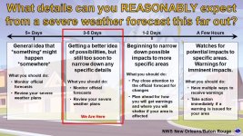
Here is his first write up for this severe event. As we get closer the details become more refined.


Post Name: Severe Weather Possible to Likely Next Week (3/02-03/03)

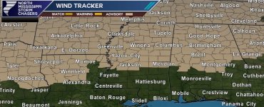
It's another week, and you know what that means. You guessed right; another severe weather threat is approaching, which could be significant. We will get into the details shortly, but here is a quick note on a few things. First, the severe weather threat out west today (Sunday) will not affect us much tomorrow across Mississippi and Alabama except for some scattered showers and wind gusts up to 40mph. Therefore, a Wind Advisory is in effect for West Tennessee, North, Central Alabama, and North and Central Mississippi until at least 04:00 PM, if not longer.
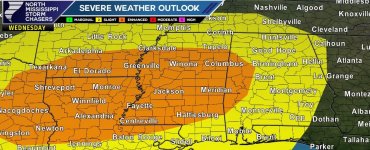
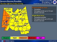
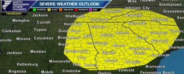
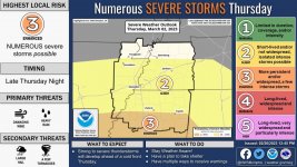
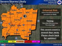
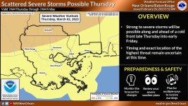
Now, let's talk about the severe weather threat for Thursday into Friday. As mentioned above, this threat could be significant as the Storm Prediction Center has its equivalent of an ENHANCED (3/5) Risk for severe weather across much of Mississippi and West Alabama. In addition, in this morning's outlook, the SPC mentioned that a "Severe Weather Outbreak is possible." Below is the text from the SPC regarding the Thursday timeframe:
On Thursday, an upper-level trough will move eastward from the Desert Southwest into the southern Plains. By late afternoon on Thursday, model forecasts develop a corridor of moderate instability in east Texas and have strong deep-layer shear over much of the southern Plains. This environment should support severe storms capable of large hail, wind damage, and perhaps some tornadoes. As a result, a widespread severe weather outbreak will be possible beginning Thursday afternoon and continuing into the overnight period. The potential for severe storms should shift eastward across the lower to mid-Mississippi Valley and into the central Gulf Coast states Thursday night where the threat for wind damage, hail, and tornadoes should continue."

NWS Jackosn and Memphis both agree that severe thunderstorms are likely Thursday going into Thursday night. Severe thunderstorms can produce tornadoes, damaging wind gusts, and large hail. This event is still several days away, so stay tuned for updates on impacts and timing over the next few days.

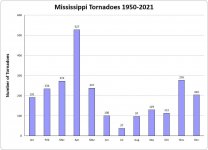
We are entering our peak severe weather season (from late October to mid-May), where nearly 40% of all tornadoes in Mississippi since 1950 occurred in March and April. So NOW is the time to prepare your severe weather action plans. We have severe weather tips on our website, and be sure to view our Severe Weather Video Series here: https://tinyurl.com/y83n4h6v

Attachments:
-Wind Advisory Graphic
-SPC Outlooks for Thursday and Friday.
-NWS Graphics
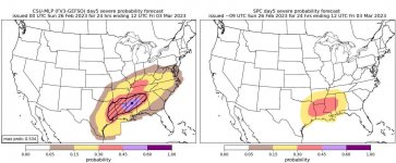
-Colorado State Probability Outlook
 

Attachments

  • 22507352-430F-4464-86E7-872421EAED4A.jpeg
    22507352-430F-4464-86E7-872421EAED4A.jpeg
    262.1 KB · Views: 8
  • 5F47DD83-4F87-434A-BE19-237575BDBD26.jpeg
    5F47DD83-4F87-434A-BE19-237575BDBD26.jpeg
    230.5 KB · Views: 6
  • 3C25053D-08E5-4820-9FCD-2E99F80FF2ED.jpeg
    3C25053D-08E5-4820-9FCD-2E99F80FF2ED.jpeg
    147 KB · Views: 7
  • E8DC2CD8-C21E-4BBC-B273-806A490EA559.jpeg
    E8DC2CD8-C21E-4BBC-B273-806A490EA559.jpeg
    258 KB · Views: 5
  • A28C6F76-813C-488B-9947-C70F9D03C723.jpeg
    A28C6F76-813C-488B-9947-C70F9D03C723.jpeg
    208.4 KB · Views: 5
  • 48BF8D20-E1A6-4DAF-ADB9-9BC2F491710F.jpeg
    48BF8D20-E1A6-4DAF-ADB9-9BC2F491710F.jpeg
    231.7 KB · Views: 6
  • 90EC665E-D82F-49C8-A997-5BEBD37E01D1.jpeg
    90EC665E-D82F-49C8-A997-5BEBD37E01D1.jpeg
    129.7 KB · Views: 7
  • 352A1A08-8038-4C9B-A4AC-C8F23CE8B89E.jpeg
    352A1A08-8038-4C9B-A4AC-C8F23CE8B89E.jpeg
    63.7 KB · Views: 8
  • 3F526176-A471-48ED-AE0E-F5E25C6C3D22.jpeg
    3F526176-A471-48ED-AE0E-F5E25C6C3D22.jpeg
    206.5 KB · Views: 7
  • 37226E37-2119-4AFA-A705-7FD206AB158D.jpeg
    37226E37-2119-4AFA-A705-7FD206AB158D.jpeg
    173.5 KB · Views: 7

IBleedMaroonDawg

Well-known member
Nov 12, 2007
23,121
7,129
113
We're gonna have some severe weather with this. Whatever form it that takes we're definitely gonna have some damaging winds.
 

Hugh's Burner Phone

Well-known member
Aug 3, 2017
4,296
3,420
113
Jackson NWS had some ominous wording in their evening discussion. For those no familiar, one thing they do is look at analogs. The computers take a look at the expected conditions for this upcoming event and compare it to past events with similar conditions to see what those past storms produced. That gives them an idea of how this storm may perform. They were saying the analogs for this storm are referencing past high end events so there is some support for this being a big deal. Far from etched in stone, though. Looking at some of the forecast soundings just a few minutes ago and I saw something that could help mitigate this being as high end as it could be. This will just be something to watch.
 
  • Like
Reactions: IBleedMaroonDawg

IBleedMaroonDawg

Well-known member
Nov 12, 2007
23,121
7,129
113
Jackson NWS had some ominous wording in their evening discussion. For those no familiar, one thing they do is look at analogs. The computers take a look at the expected conditions for this upcoming event and compare it to past events with similar conditions to see what those past storms produced. That gives them an idea of how this storm may perform. They were saying the analogs for this storm are referencing past high end events so there is some support for this being a big deal. Far from etched in stone, though. Looking at some of the forecast soundings just a few minutes ago and I saw something that could help mitigate this being as high end as it could be. This will just be something to watch.
The thing to keep in mind is we are still several days away from this event and they're already discussing it so please petition to your local weather person. It end up being very bad, but they would not already be discussing this if they did not think something was gonna happen.
 

Drebin

Well-known member
Aug 22, 2012
16,817
13,720
113
Jackson NWS had some ominous wording in their evening discussion. For those no familiar, one thing they do is look at analogs. The computers take a look at the expected conditions for this upcoming event and compare it to past events with similar conditions to see what those past storms produced. That gives them an idea of how this storm may perform. They were saying the analogs for this storm are referencing past high end events so there is some support for this being a big deal. Far from etched in stone, though. Looking at some of the forecast soundings just a few minutes ago and I saw something that could help mitigate this being as high end as it could be. This will just be something to watch.
Yeah, I think there's a chance for occlusion which could help with this. Is that what you saw?
 

Hugh's Burner Phone

Well-known member
Aug 3, 2017
4,296
3,420
113
Yeah, I think there's a chance for occlusion which could help with this. Is that what you saw?
To be honest I wasn't even looking for that. I was just looking at some of the soundings and was seeing the LCL and LFC are not close together in some of the soundings. While not an iron clad requirement I usually like those to be as close together as possible. Also, some of the morning model runs are slowing it down and peaking this system out back over central AR. Have to wait and see if this is a trend or just a one off anomaly.
 

Drebin

Well-known member
Aug 22, 2012
16,817
13,720
113
To be honest I wasn't even looking for that. I was just looking at some of the soundings and was seeing the LCL and LFC are not close together in some of the soundings. While not an iron clad requirement I usually like those to be as close together as possible. Also, some of the morning model runs are slowing it down and peaking this system out back over central AR. Have to wait and see if this is a trend or just a one off anomaly.
Yeah, it looks like the severe threat is spreading farther west with each run. Not moving, but spreading. I bring up occlusion because of the depth of the low. That could really squeeze out the size of the warm sector. To me that seems like the biggest potential mitigation here.
 

Hugh's Burner Phone

Well-known member
Aug 3, 2017
4,296
3,420
113
Yeah, it looks like the severe threat is spreading farther west with each run. Not moving, but spreading. I bring up occlusion because of the depth of the low. That could really squeeze out the size of the warm sector. To me that seems like the biggest potential mitigation here.
If it takes on a hard negative tilt that is going to up the tornado threat for somebody. Now whether somebody lives in TX, AR, or MS remains to be seen. Starting tonight the NAM will come into play and then tomorrow night the NAM3K. That will give us a little better idea of how this is playing out until the HRRR comes into play 48 hours out. Colorado State University is developing their own system to measure severe threats like the SPC and if theirs is accurate they have a large area under a 45% hatched. If, big if, the SPC agrees with that then there will be a day 3 moderate risk upgrade tonight. So I guess that means I will not be able to relax and really go to sleep until that comes out around 2:30am.
 
  • Like
Reactions: IBleedMaroonDawg

Hugh's Burner Phone

Well-known member
Aug 3, 2017
4,296
3,420
113
What I don't want is a high end severe threat blasting through the state at 3:00am and Jackson radar still being down. That would be an extremely dangerous scenario...especially for chasers out there basically driving blind at night.
 

Drebin

Well-known member
Aug 22, 2012
16,817
13,720
113
If it takes on a hard negative tilt that is going to up the tornado threat for somebody. Now whether somebody lives in TX, AR, or MS remains to be seen. Starting tonight the NAM will come into play and then tomorrow night the NAM3K. That will give us a little better idea of how this is playing out until the HRRR comes into play 48 hours out. Colorado State University is developing their own system to measure severe threats like the SPC and if theirs is accurate they have a large area under a 45% hatched. If, big if, the SPC agrees with that then there will be a day 3 moderate risk upgrade tonight. So I guess that means I will not be able to relax and really go to sleep until that comes out around 2:30am.
I agree....it's going to be bad somewhere. The models are kinda disagreeing with the where but they're all pretty consistent on the what at this point. When I was referring to mitigation, I don't mean the overall threat, just the chance that it won't be as widespread.
 
Get unlimited access today.

Pick the right plan for you.

Already a member? Login