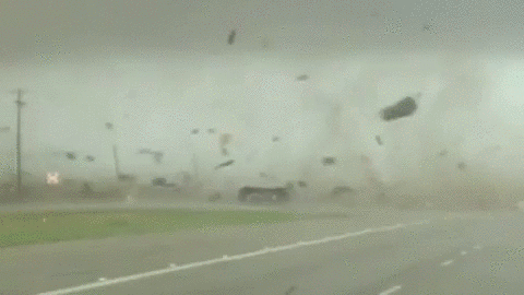
Not going to post any graphics at this time. Basically if you live anywhere in MS, eastern LA/AR, or western AL then prepare for a very bad day. The wording from the SPC for today is scary. It's given me a very bad feeling down in the pit of my stomach. I'll paste some of it below. Just realize once this event starts storms are going to go severe/tornadic very quickly. Storm speeds could be upwards of 70mph so wanting lead times could be short.
From the SPC:
A regional outbreak of severe thunderstorms is expected from the Lower Mississippi Valley into parts of the Ohio and Tennessee Valleys today, and over portions of the central Gulf Coast states later today into tonight. Widespread damaging winds with gusts over 75 mph and several strong tornadoes (EF2+) appear likely.
By midday, the combination of cooling aloft and strong low-level moisture advection will lead to destabilization near the cold front, with a rapid increase in storm coverage and intensity. Most CAMs suggest this will occur around 18Z, focused over northern LA, central and eastern AR, and southeast MO. The bulk of this activity is expected become severe as it quickly crosses the MS River into MS, western TN and KY.
Extreme shear is forecast, with effective SRH of 500-800 m2/s2 common as MLCAPE increases to 1000-1500 J/kg over LA/AR/MS and southwest TN. Supercells are likely, with strong tornadoes possible as well as particularly damaging outflow surges. As outflows merge, QLCS tornadoes may occur as well. Although CAPE values will be lower across the OH Valley, strong lift may sustain a severe-wind threat there through about 03Z.
...Parts of eastern LA...much of MS...AL...FL Panhandle... Southern portions of the front/dryline will move much slower compared to farther north, resulting in a longer duration of boundary-layer moistening. A line of convection should become evident by 21Z from southwest MS into parts of southern LA, moving across MS and into north-central AL by about 03Z. The subtle lift, combined with ample low-level moisture beneath an intense low-level jet, will favor tornadic supercells which may peak during the night. Effective SRH will remain high, averaging 400-500 m2/s2, with proper hodograph elongation in the mid and high levels. Given the long duration and slow eastward movement of this line of supercells, and the magnitude of the forecast hodographs, a few intense tornadoes could occur.