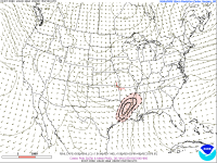
Another severe threat may be unfolding for parts of the state for Wednesday into Wednesday night. There's still some uncertainty as to how significant it may be, but potential could be there for a big event.
We know wind shear will be strong and veering with height which will create long looping hodographs favorable for storm rotation. What is still uncertain is how much instability will be in place prior to the cold front arriving. If ample instability does find its way into the state then the atmosphere will be primed for a significant severe weather event with discrete supercells forming out in the warm sector ahead of the cold front. If it looks to be less then the threat will correspondingly decrease and be primarily limited to a squall line right along the front. The below graphic is from the SPC this morning. Jackson NWS takes the threat north to and east to include the Highway 82 corridor. Hopefully, the details will work themselves out in the next 24-36 hours.
Some of us with our chase team are already making preparations to be out monitoring the storms if it looks to be a significant event. Our social media guy will be making updates on our Patreon site and any live streams can also be found there at Patreon.com/nmscas. Since the potential is there not only for this event Wednesday, but for subsequent events as well over the next 5-10 days, you may find a couple of videos on our YouTube channel of benefit. Particularly the one dealing with taking shelter during severe weather. It's link is:
A lot of you subscribe to our YouTube channel and we greatly appreciate it. And some of you may be Patreon supporters of ours and we greatly appreciate that,

Last edited:
