Hurricane Helene seems like it could mess up a bunch of CFB games this weekend.
- Thread starter Nittering Nabob
- Start date
You are using an out of date browser. It may not display this or other websites correctly.
You should upgrade or use an alternative browser.
You should upgrade or use an alternative browser.

Alabama A&M-FAMU postponed due to Helene
Florida A&M University postponed its upcoming college football game against Alabama A&M because of Tropical Storm Helene.
It would seem a lot of SEC games will be cancelled
That can’t be. I thought it ‘just means more’ down there.
")
Seriously, good luck to anyone in the path of the hurricane. Hope everyone evacuates where needed and stays safe.
Hurricane NIL has already devastated the sport beyond repair.

![[Image of Rainfall Potential]](https://www.nhc.noaa.gov/storm_graphics/AT09/refresh/AL0924WPCQPF+gif/033010WPCQPF_sm.gif "[Image of Rainfall Potential]")

We were just talking about this. All of FL going to be affected, but unless there is a lot of flood and/or wind damage at the venues hosting games the games should go on as scheduled. The rain and winds should be gone from FL by sometime Friday.
However, GA, TN and other southern states that are going to be impacted are likely to have games canceled. The rains are supposed to continue through Saturday in those areas due to the merger of the hurricane with the other rain front coming through the south.
However, GA, TN and other southern states that are going to be impacted are likely to have games canceled. The rains are supposed to continue through Saturday in those areas due to the merger of the hurricane with the other rain front coming through the south.
Ugh. Looks like the heaviest rain will be in the mountains of NC/SC/GA. That's a recipe for some serious flooding in the valleys.
Looks like a great weekend to run Currahee!
also may impact the Braves-Royals series, of importance in the wild card races.
Last edited:
As well as the Braves-Mets tomorrow night. Could force them to play a game on Monday.Looks like a great weekend to run Currahee!
also may impact the Braves-Royals series, of importance in the wild card races.
Probably a double header.As well as the Braves-Mets tomorrow night. Could force them to play a game on Monday.
Pour some Sugar on Me!
By Velveeta. Best cover band in State College in the 90’s.
They should play the concert in between the games.
Nonsense. Unless it is lightning, play on. Those southern boys are way too soft when it comes to inclimate weather.It would seem a lot of SEC games will be cancelled
They played the block party outside the stadium on Saturday.Pour some Sugar on Me!
By Velveeta. Best cover band in State College in the 90’s.
In between innings.They should play the concert in between the games.
During the games.They should play the concert in between the games.
da u had better play. They’re the f*cking Hurricanes. It’s who they are.


Can they cancel Minnesota at Michigan? Asking for a team friend...

Given the shape of that storm, western Kentucky/Tennessee may be screwed!
Nonsense. Unless it is lightning, play on. Those southern boys are way too soft when it comes to inclimate weather.
Remember the bowl game against LSU? They complained bitterly about having to play in the rain on a torn-up field. Lucky for us, Penn State didn't have the same conditions - oh, wait!!
I'm sure it will change, but been very quiet on the Right Coast so far.....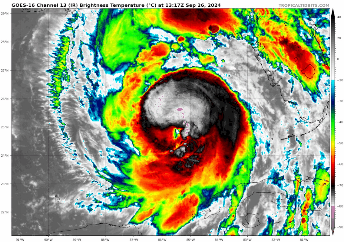
Nasty looking storm. Good thing it's fast moving. Wouldn't want to be looking at that over here on the east coast right now.
Had our moments w/ some bands in Juno this AM. Club is open, but no one playing in Tequesta. Lots of limbs down.I'm sure it will change, but been very quiet on the Right Coast so far.....
In your IR sat pic, I was waiting for that big cell rotating off Lake Okeechobee, but look how it just falls apart as it approaches the Space CoastHad our moments w/ some bands in Juno this AM. Club is open, but no one playing in Tequesta. Lots of limbs down.
Yes this morning was much worse than its been since. Heavy band and winds then pretty much mostly sun and some winds. Looks like its jogging more east, I think Cedar Key is going to take this on the chin. Tallahassee will be on the west side and not get as much damage now.Had our moments w/ some bands in Juno this AM. Club is open, but no one playing in Tequesta. Lots of limbs down.
I was thinking the same thing. Not sure that far inland will be used to such a heavy amount of rain.Given the shape of that storm, western Kentucky/Tennessee may be screwed!
From the latest update, it looks like its going to spend ~24 hours sitting right over western KY (Bowling Green) and north central TN (Nashville).

Looks like the eye wall is closing. Intensity about to begin probably. There is some wobbling. We'll see.Yes this morning was much worse than its been since. Heavy band and winds then pretty much mostly sun and some winds. Looks like its jogging more east, I think Cedar Key is going to take this on the chin. Tallahassee will be on the west side and not get as much damage now.
Yup... unexpected dry air and shear kept this from wrapping up much sooner and many can be thankful for that. Just starting to get its act together.Looks like the eye wall is closing. Intensity about to begin probably. There is some wobbling. We'll see.
I was thinking the same thing. Not sure that far inland will be used to such a heavy amount of rain.
From the latest update, it looks like its going to spend ~24 hours sitting right over western KY (Bowling Green) and north central TN (Nashville).
View attachment 658253
Yes it's going to end up spinning around a upper cut off low pressure system and eventually combine with it. With the more eastern track that is why everyone is now seeing rain showers make it into PA this weekend when originally the whole storm was supposed to be all in TN/KY.
Actually some of the models predicted the dry air inclusion pretty well, and intensification was going to be this afternoon and evening.Hitting unexpected dry air/shear why its not wrapping up quicker. Also leaves it more susceptible to the lower united states steering with that approaching frontal boundary. Why you see it more east than projected and now Tampa with the storm surge better be ready.
You're right about Tampa Bay needing to be watching....the storm has consistently been running east of the forecast track.
Latest posts
-

-
 “Ex-Vikings QB Tommy Kramer says he has dementia”
- Latest: EricStratton-RushChairman
-
-

Get unlimited access today.