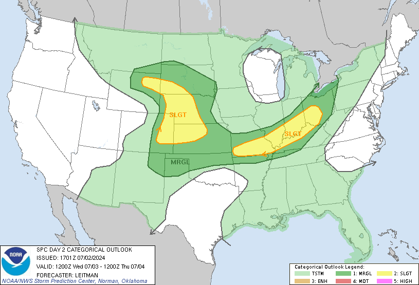
Next Severe Threat Wednesday

Hugh's Burner Phone

Well-known member
Aug 3, 2017
4,314
3,460
113
Our next severe threat looks to materialize on Wednesday. Too soon to talk specifics, but at this time it looks to be another wind/tornado threat with hail a secondary issue.


From the SPC:
[FONT=lucida sans typewriter, lucida console, courier]GUIDANCE CURRENTLY SUGGESTS THE LOW- AND MID-LEVEL WINDS WILL
STRENGTHEN ON D6/WEDNESDAY, RESULTING IN VERY IMPRESSIVE WIND
PROFILES. THIS STRENGTHENING OF THE FLOW, COUPLED WITH THE
NEGATIVELY TILTED CHARACTER TO THE SHORTWAVE AND AMPLE LOW-LEVEL
MOISTURE, SUGGESTS THE POTENTIAL FOR NUMEROUS SEVERE STORMS EXISTS.
AS A RESULT, HIGHER SEVERE PROBABILITIES MAY BE NEEDED IN LATER
OUTLOOKS IF THE CURRENT TRENDS WITHIN THE GUIDANCE PERSIST.[/FONT]


Hugh's Burner Phone

Well-known member
Aug 3, 2017
4,314
3,460
113
Upgrade to an enhanced risk. However, the threat look to be evolving into more of a straight line wind threat and less of a tornado threat. Just got to see how it all shakes out.


IBleedMaroonDawg

Well-known member
Nov 12, 2007
23,182
7,207
113
The guys on one of my websites are talking about the fact that there are signs that it may be a very busy and Storm spring Severe Weather season. They were discussing things I barely understand like Nina/-PDO/-ENSO/+TNI
 

Hugh's Burner Phone

Well-known member
Aug 3, 2017
4,314
3,460
113
The guys on one of my websites are talking about the fact that there are signs that it may be a very busy and Storm spring Severe Weather season. They were discussing things I barely understand like Nina/-PDO/-ENSO/+TNI

I don't understand all that either. ENSO is something something southern oscillation.
 

Hugh's Burner Phone

Well-known member
Aug 3, 2017
4,314
3,460
113
Latest from the SPC concerning Wednesday:

An appreciable severe-weather risk appears increasingly likely across the Lower Mississippi Valley and Middle Gulf Coast region on Wednesday/Day 4. This includes the potential for widespread damaging winds and tornadoes, including the possibility of a regional-type tornado outbreak including strong (EF2+) tornadoes.
 

LanierDawg

New member
Aug 24, 2012
81
7
8
Do any of Ya’ll follow Ryan Hall Ya’ll’s reporting online? He has a video in YT out about Wednesday and the severe potential
 

Hugh's Burner Phone

Well-known member
Aug 3, 2017
4,314
3,460
113
The HRR is just now starting to pick up on the beginning of the Wednesday event. So far it is following along with the mid range models and making this a qlcs event with embedded tornadic circulations. What that means is, if this holds, is a significant straight line wind event with a few tornadoes spinning up. It currently goes out to 1:00pm Wednesday and is not showing much in the way of discrete supercell activity which should greatly reduce both the number and strength of tornadoes. The 00z run will be in around 9:30-10:00 and it will be the first run to cover almost the entire event.
 

IBleedMaroonDawg

Well-known member
Nov 12, 2007
23,182
7,207
113
The HRR is just now starting to pick up on the beginning of the Wednesday event. So far it is following along with the mid range models and making this a qlcs event with embedded tornadic circulations. What that means is, if this holds, is a significant straight line wind event with a few tornadoes spinning up. It currently goes out to 1:00pm Wednesday and is not showing much in the way of discrete supercell activity which should greatly reduce both the number and strength of tornadoes. The 00z run will be in around 9:30-10:00 and it will be the first run to cover almost the entire event.

It can change and the linear mode can cause a lot of damage and problems.
click on the image
View attachment 24178


You guys need to watch the next system on April 6-8

View attachment 24177
 

Hugh's Burner Phone

Well-known member
Aug 3, 2017
4,314
3,460
113
Oh no doubt. This system will have winds up to 60mph prestorms. The storms may push 70-80.

I've been watching next week very closely but didn't want to mention it yet until we got through this one. But yes, early signs are pointing to that next one being big.
 

IBleedMaroonDawg

Well-known member
Nov 12, 2007
23,182
7,207
113
View attachment 24180

Expectation is that
these robust wind fields will result in an intense convective line
capable of widespread wind damage. Embedded/QLCS tornadoes are also
likely within this environment, including the potential for strong
tornadoes (EF2+). Fast storm motion could result in longer-track
QLCS tornadoes than are typically observed.

In addition to the strong wind gusts and embedded QLCS tornadoes,
discrete supercells ahead of and/or south of the primary convective
line are also possible. Any discrete storm that is able to mature
and deepen would likely become an intense supercell capable of
producing severe wind gusts and strong tornadoes. However, the
forcing for ascent and fast-moving character of the shortwave (as
well as the convective line) do not favor a discrete convective
mode, and the current expectation is for the linear mode to
dominate.
 

msudawg12

Active member
Dec 9, 2008
3,681
334
83
To ask the important question, i am supposed ro be landing in Meridian at 4:26 PM Wednesday. How bad will it be and am i getting home?
 

Hugh's Burner Phone

Well-known member
Aug 3, 2017
4,314
3,460
113
To ask the important question, i am supposed ro be landing in Meridian at 4:26 PM Wednesday. How bad will it be and am i getting home?

You'll be landing just ahead of the line that should be pushing through between 6:00-7:00 last I timed it out. So depending on where Horne is you might have a bumpy drive home.
 

Lucky Dawg

Member
Oct 8, 2012
104
15
17
Fantastic. We’re driving from Memphis to Birmingham tomorrow. Was planning to leave after work but looks like we’ll need to leave no later than ~2pm to stay ahead of the storm.
 

maroonmadman

Well-known member
Nov 7, 2010
2,421
541
113
Passed through Goodman on Sunday to go check storm damage on my property in Attala Co. I don't think there was a single building in town that didn't have some sort of damage to it. Every building on Main St. had windows blown out and roof damage. Lots of timber damage in west Attala Co. between Sallis and the Big Black river and to the north of Sallis. My pieces of property (2) escaped any major damage.
 

DerHntr

Well-known member
Sep 18, 2007
15,242
1,193
113
It appears Landmass will get some severe weather tomorrow. All of landmass.
 

cowbell88

Well-known member
Jan 11, 2009
2,879
509
113
All schools in central MS public and private have already canceled for tomorrow. Gonna be rough.
 

mcdawg22

Well-known member
Sep 18, 2004
11,026
4,997
113
Okay I have to say this. The nomenclature is so dumb. An enhanced risk seems more perilous than a moderate risk. Not to mention that significant risk for winds is on the table. Who comes up with this ****? Moderate to me seems nominal like, it’s possible but whatever, maybe. Like Orange Cassidy in AEW. Enhanced seems like, okay, I’m on my toes, like Chris Jericho in AEW. A significant risk seems like Jon Moxley in AEW.
 

Hugh's Burner Phone

Well-known member
Aug 3, 2017
4,314
3,460
113
Okay I have to say this. The nomenclature is so dumb. An enhanced risk seems more perilous than a moderate risk. Not to mention that significant risk for winds is on the table. Who comes up with this ****? Moderate to me seems nominal like, it’s possible but whatever, maybe. Like Orange Cassidy in AEW. Enhanced seems like, okay, I’m on my toes, like Chris Jericho in AEW. A significant risk seems like Jon Moxley in AEW.

Enhanced was added just a few years ago to split up the slight risk. Before that was all slight. So you went marginal, slight, moderate, high. And you're not alone in your thinking on that. A lot of people in the general public agree with you. However, the threat guideline was not developed for use by the general public. It was developed for other meteorologists and at the time was how they thought best to split it up and name the levels. It was just until the last 10-15 years that the general public started being exposed to them when network Mets started using them in their forecasts. By then the levels had become very entrenched in their values by those they were developed for so don't look for them to change. On my storm team YouTube channel I have a video that breaks down the criteria for each level by threat. It's the first video in a five part series on severe weather.
 

Hugh's Burner Phone

Well-known member
Aug 3, 2017
4,314
3,460
113
Wording from the SPC is scary as hell in their latest outlook. I beg you to take all warnings very seriously and realize warning times may be short.
 
Get unlimited access today.

Pick the right plan for you.

Already a member? Login