Severe Wednesday / Significant severe Thursday

Hugh's Burner Phone

Well-known member
Aug 3, 2017
4,296
3,420
113
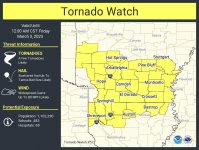
Today is what has looked to be the main event since last week. I still think the worst of the worst will be well off to the west of MS, but the SPC maintains parts of the state in an enhanced risk with hatched threats for tornadoes and wind. Timing of the storms for MS will be well after dark and they may be after sunrise Friday morning pushing out of the eastern part of the state. I expect primary storm mode to be linear for the state. A midlevel capping inversion cold also dampen storm potential. But even if the line is linear there is enough shear to allow for QLCS embedded tornadoes and a few of them could be strong. Just have multiple ways to get weather alerts tonight. Detailed information is also available on our patreon page at www.patreon.com/NMSCAS. Hopefully y'all don't mind my shameless plugs of that site.


  • Like
Reactions: DerHntr

Hugh's Burner Phone

Well-known member
Aug 3, 2017
4,296
3,420
113
Hugh, Just cause we don't all reply when you post doesn't mean we aren't watching and reading. Thanks again for taking the time to do this.
You're quite welcome. I was just hoping me more often mentioning our subscription Patreon site wasn't rubbing people the wrong way. We've been struggling to gain subscribers so I thought I would mention it here and elsewhere. Especially since y'all came through so big on the YouTube subscription push. I know this is completely different since it requires actual money, though. Not a lot, but when eggs cost $7 a buck is a buck.
 

RocketDawg

Active member
Oct 21, 2011
16,382
368
83
Huntsville with a warning now. The storm is pretty damn big.
Things were really loud last night with lots of rain, wind, and some of the worst thunder I've heard. There was an apparent spin-up in the north county area around 10 that damaged a couple of houses. I don't think it was ever warned by the NWS but Brad Travis on WAFF noticed and followed it.
 

IBleedMaroonDawg

Well-known member
Nov 12, 2007
23,117
7,127
113
You're quite welcome. I was just hoping me more often mentioning our subscription Patreon site wasn't rubbing people the wrong way. We've been struggling to gain subscribers so I thought I would mention it here and elsewhere. Especially since y'all came through so big on the YouTube subscription push. I know this is completely different since it requires actual money, though. Not a lot, but when eggs cost $7 a buck is a buck.
You should've came over here today. The Cap just broke from south of Dallas over towards Louisiana. It just might get crazy here very soon.
 

horshack.sixpack

Well-known member
Oct 30, 2012
9,065
5,068
113
SPC has upgraded NW MS to a slight risk for severe weather Wednesday for a conditional low end event and maintaining a significant severe weather event possible late Thursday afternoon into Thursday night. As I was expecting, they did retract the threat back slightly westward for Thursday as it looks like the timing of the storm has slowed slightly. By the time the storms reach the golden triangle area the system will be weakening as the best dynamics start to pull away from the region. However, parts of western and central MS are still fully under the gun and the SPC is saying an upgrade to a moderate risk is likely with the threat for damaging winds and tornadoes (some strong) in the black hatched area. I would not be surprised if most of any mod risk is in parts of AR and LA and possibly extending into the delta region. Just have to see how it plays out.
Central MS seems to be avoiding most of the potential danger?
 

DesotoCountyDawg

Well-known member
Nov 16, 2005
22,102
9,443
113
Man that supercell along the Oklahoma Texas border is a monster. Looks like it’s got some big hail in it.
 

Hugh's Burner Phone

Well-known member
Aug 3, 2017
4,296
3,420
113
They should avoid the worst of the worst, but could still see a severe storm. Big key is west. Further west you are the higher your chance of seeing some type of severe weather is. Then tomorrow it emails back up again to a lesser extent over in GA and east TN.
 

IBleedMaroonDawg

Well-known member
Nov 12, 2007
23,117
7,127
113
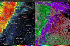
It is storming like crazy here! Right after that just passed me. It went tornado warned. I'm in the around the X. I put this up because I know there are some other people around me on the board. torwarn.jpg
 

IBleedMaroonDawg

Well-known member
Nov 12, 2007
23,117
7,127
113
These are your textbook QLCS spin up mesovortices. Fast moving, rain wrapped, and usually quick lived.
You are correct but since they got to interstate 35 and started moving east, they seem to be picking up steam. The atmosphere east of us must really be ready to fire off. It acts like the overall low pressure system is building up some strength I would have my eye open from here all the way to Georgia through tomorrow
 

Hugh's Burner Phone

Well-known member
Aug 3, 2017
4,296
3,420
113
You are correct but since they got to interstate 35 and started moving east, they seem to be picking up steam. The atmosphere east of us must really be ready to fire off. It acts like the overall low pressure system is building up some strength I would have my eye open from here all the way to Georgia through tomorrow
It's hitting its peak now. Parameters are as good as it gets right now. Once the storm approaches the MS river daytime heating will be lost and the low pressure center will have begun to move off to the NE and remove some of the forcing. That will cause the storms to start to weaken. Tomorrow, though, as daytime heating kick back in, the ingredients start to come back into play and the severe threat ramps back up over TN and KY.
 

IBleedMaroonDawg

Well-known member
Nov 12, 2007
23,117
7,127
113
It's losing steam over here now there may be some bad storms blow up around East Texas, Arkansas, Louisiana but I think we're good until this system gets over towards your direction. Be careful.
 

Hugh's Burner Phone

Well-known member
Aug 3, 2017
4,296
3,420
113
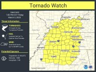
Line of storms now in MS. Currently, none are severe but some are just below. A tornado watch will soon be issued for NE MS as they anticipate the lien starting to intensify a little later this morning. Storms or not, very strong winds are across the state with gusts over the delta approaching 60mph. Be careful driving and watch for downed trees that haven't been discovered yet.
 

Treemydawg

Member
Sep 29, 2013
272
43
28
97C06807-93D3-40F8-92F5-0A7BC91B8F7A.jpegI’m going through Greenville pulling this load and the wind is kicking my butt
 
Last edited:

Hugh's Burner Phone

Well-known member
Aug 3, 2017
4,296
3,420
113
Severe weather looks to mostly be out of the state now, but we will still have some gusty winds. My chase luck continues as I was set up perfectly on a storm just south of Tupelo that had rotation and it passed right over the top of me. 10 minutes later it got a tornado warning. Don't think anything touched down which is good since it was passing over populated areas. I have seen some reports of wind damage including one tree down on a house so the line was packing a punch as it moved through.
 

msudawg12

Active member
Dec 9, 2008
3,677
332
83
I am extremely glad that we didnt get any severe weather (Meridian) but damn man.... We didnt even get enough rain to wash away the pollen.
 
Get unlimited access today.

Pick the right plan for you.

Already a member? Login