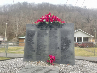
50th anniversary of Pittston Coal Co. coal slurry dam disaster, in WV

PAgeologist

Active member
Oct 19, 2021
285
348
63

The Knox mine disaster essentially ended deep mining in a big part of the anthracite field. Many of the mines were connected. That had to be astronomically horrifying to go through.

More recently, Quecreek was similar but not nearly as catastrophic. They broke into an adjacent abandoned deep mine which was flooded. Knox broke into the Susquehanna.
 
  • Like
Reactions: TheGlovStillRules

PAgeologist

Active member
Oct 19, 2021
285
348
63
@PAgeologist
Thanks WD, I grew up in the Wyoming Valley and remember the Susquehanna flooding the deep mines. I was in fifth grade, living with my grandparents in Edwardsville. My grandfather was a blaster at the Lorre Colliery in Larksville.
If your still out that way, I recommend the Lackawanna Mine Tour. It gives a pretty good perspective on what an anthracite mine looked like.

For those in western PA, try the Tour Ed Mine Tour. It's a good one for a look into a bituminous mine. They also go through some mining methodology history. Wouldn't recommend if you're claustrophobic.
 

PAgeologist

Active member
Oct 19, 2021
285
348
63
Yep, live in Lehman, about 17 miles nw from the Susquehanna River at Wilkes-Barre.
Lackawanna mine is a sloped shaft leading to the mining galleries,
Visiting up there makes me happy I deal with western PA. There is some very unique and complex geologic structure up there. Nothing like having to figure out how to mine a nearly vertical coal seam and traverse through those tight folds.
 
  • Like
Reactions: TheGlovStillRules

PAgeologist

Active member
Oct 19, 2021
285
348
63
Yep, live in Lehman, about 17 miles nw from the Susquehanna River at Wilkes-Barre.
Lackawanna mine is a sloped shaft leading to the mining galleries,
I thought of something else that would probably be up your alley. Check out the PASDA website. All sorts of historic aerial photos and maps as well as georeferenced scans of deep mine maps. All free for viewing or download. No account needed either. And fairly user friendly.
 

step.eng69

Well-known member
Oct 12, 2021
2,789
3,927
113
I thought of something else that would probably be up your alley. Check out the PASDA website. All sorts of historic aerial photos and maps as well as georeferenced scans of deep mine maps. All free for viewing or download. No account needed either. And fairly user friendly.
Thank you PAgeo, I'm off on Mondays & Fridays. I did run across a PASDA site that featured mining maps & other information about the mining regions. Since I was off yesterday, I didn't have the advantage of my 21" computer screen to view the old mining maps.

When we were kids, 10-12 yrs old, we'd buy candles and explore these 4' x 4' brick lined passage ways buried underground. they were located near Grove Street in Edwardsville. I believe they were slightly sloped air passageways that provided additional ventilation to the vertical shafts. The ceiling of the shafts were about 4' below ground, we entered the shafts through a small void in the ground (portion of ceiling collapse).

I was trying to located the entities in the mining maps yesterday, but the pad I was using didn't provide enough resolution.
 
  • Like
Reactions: TheGlovStillRules

PAgeologist

Active member
Oct 19, 2021
285
348
63
Thank you PAgeo, I'm off on Mondays & Fridays. I did run across a PASDA site that featured mining maps & other information about the mining regions. Since I was off yesterday, I didn't have the advantage of my 21" computer screen to view the old mining maps.

When we were kids, 10-12 yrs old, we'd buy candles and explore these 4' x 4' brick lined passage ways buried underground. they were located near Grove Street in Edwardsville. I believe they were slightly sloped air passageways that provided additional ventilation to the vertical shafts. The ceiling of the shafts were about 4' below ground, we entered the shafts through a small void in the ground (portion of ceiling collapse).

I was trying to located the entities in the mining maps yesterday, but the pad I was using didn't provide enough resolution.
I would guess they may have been old slope entries or drainage tunnels which were pushed closed and later collapsed. Any railroad tracks for an entry probably have been removed and used elsewhere. There are several very large drainage tunnels in the anthracite region. Most put out excess of 10000 gpm of mine drainage.

At least in western PA, most ventilation shafts were vertical. More modern mines used sloped ventilation tunnels with large fans. The earliest mines used fires over the shaft to create a draft through the mine. Then I believe they used a donkey on a pulley system to run a fan.

Those old miners were tough, hard working, yet inventive people. There was a large amount of mining done in this state without the use of any electricity, power tools, and trains. I'm also amazed at the accuracy they managed to map out the mine. A lot of those circa 1900 maps are spot on.
 

step.eng69

Well-known member
Oct 12, 2021
2,789
3,927
113
I would guess they may have been old slope entries or drainage tunnels which were pushed closed and later collapsed. Any railroad tracks for an entry probably have been removed and used elsewhere. There are several very large drainage tunnels in the anthracite region. Most put out excess of 10000 gpm of mine drainage.

At least in western PA, most ventilation shafts were vertical. More modern mines used sloped ventilation tunnels with large fans. The earliest mines used fires over the shaft to create a draft through the mine. Then I believe they used a donkey on a pulley system to run a fan.

Those old miners were tough, hard working, yet inventive people. There was a large amount of mining done in this state without the use of any electricity, power tools, and trains. I'm also amazed at the accuracy they managed to map out the mine. A lot of those circa 1900 maps are spot on.
I've been in construction surveying about 50% of my life. As I am very familiar to the equipment used to map the mining operations back then, it is a tremendous feat to establish survey control bench marks from ground level and establish control bench marks to each of the thousands of mining gang ways established every 50 feet below ground for hundreds of feet.
Amazing...
 

PAgeologist

Active member
Oct 19, 2021
285
348
63
Thank you PAgeo, I'm off on Mondays & Fridays. I did run across a PASDA site that featured mining maps & other information about the mining regions. Since I was off yesterday, I didn't have the advantage of my 21" computer screen to view the old mining maps.

When we were kids, 10-12 yrs old, we'd buy candles and explore these 4' x 4' brick lined passage ways buried underground. they were located near Grove Street in Edwardsville. I believe they were slightly sloped air passageways that provided additional ventilation to the vertical shafts. The ceiling of the shafts were about 4' below ground, we entered the shafts through a small void in the ground (portion of ceiling collapse).

I was trying to located the entities in the mining maps yesterday, but the pad I was using didn't provide enough resolution.
I dug through a couple maps of that area. There were several shafts and tunnels in the vicinity. I'm not familiar enough with the map layouts and mining procedures up there to determine what all they were. Mining in that region is completely different than western PA. I'm guessing they're entries, air shafts and possibly power boreholes. I did see at least 1 tunnel between mines in adjacent coal seams but that shouldn't have any part on the surface.

If you look, many maps have elevations on them indicating the bottom of the coal seam. You can see how steep the grade was as they were chasing the seams. Most coal in western PA has a 1-2 percent grade.
 

step.eng69

Well-known member
Oct 12, 2021
2,789
3,927
113
I would guess they may have been old slope entries or drainage tunnels which were pushed closed and later collapsed. Any railroad tracks for an entry probably have been removed and used elsewhere. There are several very large drainage tunnels in the anthracite region. Most put out excess of 10000 gpm of mine drainage.

At least in western PA, most ventilation shafts were vertical. More modern mines used sloped ventilation tunnels with large fans. The earliest mines used fires over the shaft to create a draft through the mine. Then I believe they used a donkey on a pulley system to run a fan.

Those old miners were tough, hard working, yet inventive people. There was a large amount of mining done in this state without the use of any electricity, power tools, and trains. I'm also amazed at the accuracy they managed to map out the mine. A lot of those circa 1900 maps are spot on.
You have very interesting posts PAgeo,
Thank you for your information.
 
Get unlimited access today.

Pick the right plan for you.

Already a member? Login